Chesapeake Community Modeling Program
the new CCMP Newsletter | April 2009
Volume 2, Issue 2
Introduction
There have been many interesting developments in modeling for the Chesapeake Bay recently. First, during the Ecosystem Based Management (EBM) conference in March, it became very clear that the Chesapeake Bay Program has now decided to continu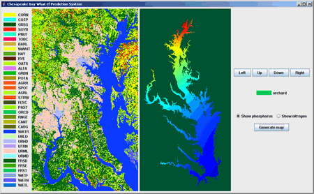 e full speed ahead with further development of its modeling suite based on HSPF. At the same time, there is now the Chesapeake Bay Forecasting System (CBFS) that we presented in the previous Newsletter. It will provide similar functionality as well as some additional features. It also appears that the US ACE Environmental Research and Development Center is getting interested in modeling watersheds.
There has been good progress with the development of the Chesapeake Inundation Prediction System (CIPS ). At the same time there is the Inundation Modeling Community created at NOAA. It is yet to be determined how the two will work together.
We are seeing a lot of parallel efforts. Could the collaborative, community way to develop models and tools perhaps be a better way forward particularly when multi-million investments and years of work are being discussed.

Contents
1. CCMP News in brief
2. News from other communities
3. Open Source on the March
4. Featured Modeler: Chris Duffy
5. Featured Model: LTRANS
1. CCMP News in Brief
First workshop of the Chesapeake Focus Research Group of CSDMS
 As we reported in August last year ,the Community Surface Dynamics Modeling System (CSDMS) and CCMP have formed a Geographically-Focused Research Group (GFRG) associated with CSDMS. The Chesapeake GFRG had its first workshop on April 3rd in Annapolis. The report from the workshop can be found on the web site of the group. Eleven people attended and discussed various aspects of integration between CSDMS and CCMP. A number of action points and goals were identified for this year. Carl Friedrichs has been recommended by the group as Chair and was appointed by the CSDMS Executive Director. The next meeting of the Chesapeake GFRG will take place in the fall, probably in November.
It has been noted that since most of the research issues seem to be the focus of CSDMS, perhaps CCMP might consider working within CSDMS to address regional research needs, this would allow CCMP to focus more on applications and work with model users to improve the decision making process. It was decided that one of the priorities of the group will be to seek funding for a liaison person who could be hired by CCMP and spend some time at the CSDMS Integration Facility in Boulder to get more experience with the model-linking tools and methods developed there.
Discussing the Vision for the future Chesapeake Modeling Suite (CMS)
We have concluded our survey on the future CMS. There were a total 55 responses from the web and during the CRC Regional Conference on Ecosystem Based Management (EBM), March 22-25, 2009. We feel that the volume of responses is quite good and probably sufficiently representative to draw some conclusions. The full report is available here.
Most of the respondents represented the science and research community, so we still only have a very general idea of what the other stakeholders and users have to say about our models. Almost all participants had some level of experience with models and more than half had a good knowledge of models.
According to the survey results, HSPF is the best-known model used for the Bay, followed by SPARROW and CE-QUAL-ICM. The CBP monitoring database is the most widely used source of data.
The majority of respondents feel quite strongly about the need to promote open source models, almost half believing that open source should be “a must”. The majority prefers models of intermediate complexity, with the overall distribution skewed towards complex models. Nobody wants models to be overly simple.
The problems that are important for the Bay are heavily dominated by ecological issues (eutrophication, hypoxia), with less importance attached to economics and social dynamics.
Nobody wants a one number type of solution from a model. The majority is interested in the model itself to play with and analyze. About a third of respondents would prefer to have several models to choose from.
There is consensus concerning stakeholder engagement. Many agree that stakeholders should be a part of the modeling process and the majority feels quite strong about it. Among those who had the opportunity to be part of a participatory modeling process, most have found the experience quite rewarding.
Finally there is an overwhelming opinion that decision-making will benefit most from hierarchical models that can be adapted to particular needs and problems.
As a result of the survey we have also identified 19 people who wished to continue being involved in this discussion in the future. We intend to put together a discussion group for these people and will continue our work on the Vision. Our first goal will be a series of publications on various aspects of the future modeling efforts for the Bay.
2. News From Other Communities
Community Hydrologic Modeling Platform (CHyMP)
 The CUAHSI (Consortium of Universities for the Advancement of Hydrologic Science, Incorporated) program for Hydrologic Modeling (CHyMP) held its 2nd Workshop on March 31 – April 1, 2009 at University of Memphis. The goal was to develop a Blueprint for a CHyMP. The presentations and summaries of discussions are available.
Community for Integrated Environmental Modeling (CIEM)
CIEM, also known as “Integrated Modeling for the Environment” (IM4E), is slowly gaining momentum. After the Phoenix workshop there have been some slowly developing discussions on the Google Group, culminating in a recent conference call discussion of a preliminary description of a web-facilitated Community of Practice (CoP) for integrated modeling and technology. The EPA is providing some funding to develop a web portal to support integrated modeling and CIEM is now actively discussing the features and foci of this portal. There seems to be a growing consensus that the Community will try to position itself as a Community of Communities to avoid the ‘reinventing the wheel’ syndrome and to provide real integration services in terms of models, data and people to the other Communities already in place.
UVA Launches Bay Game
 On Earth Day (April 22) the University of Virginia (UVA) debuted the UVA Bay Game. The game allows student players to make decisions as a Bay stakeholder (farmer, waterman, developer or policy maker) and see the response of the Bay to those decisions.
The game models seven Bay watersheds (Susquehanna, Patuxent, Eastern Shore, Potomac, Rappahannock, York and James) using the STELLA modeling software from Isee System, Inc. The games front end was developed using Forio from Forio, Inc.
The software constitutes version 0.9. Further game development will occur over the summer with a subsequent release of version 1.0 in the summer or fall. Further information about the game can be found here.
3. Open Source on the March
Python or MATLAB
 For those MATLAB lovers there is now an open source alternative to consider. MATLAB and NumPy/SciPy have a lot in common. There are also differences, since NumPy and SciPy were created for numerical and scientific computing with Python: they are not supposed to be MATLAB clones. However many MATLAB users find that most of the functionality they need can be provided by this free and open source alternative.
NumPy contains:
- a powerful N-dimensional array object
- sophisticated broadcasting functions
- basic linear algebra functions
- basic Fourier transforms
- sophisticated random number capabilities
- tools for integrating Fortran code
- tools for integrating C/C++ code
Besides its obvious scientific uses, NumPy can also be used as an efficient multi-dimensional container of generic data. Arbitrary data-types can be defined. This allows NumPy to seamlessly and speedily integrate with a wide variety of databases.
A helpful list of commands that compares MATLAB and NumPy is available here. One advantage of MATLAB is the large number of additional toolboxes that are available, including the Simulink packages. NumPy, on the other hand, has the advantage that Python is a more modern and complete programming language and is open source. Other complementary Python packages are also available: SciPy is a library that adds more MATLAB-like functionality; Matplotlib is a plotting package that provides MATLAB-like plotting functionality. Internally, both MATLAB and NumPy rely on LAPACK for efficient linear algebra computations. There is also a vibrant and rapidly growing user community that supports NumPy.
So these new options might be worth considering...
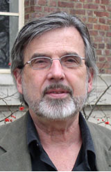
4. Featured Modeler: Chris Duffy
 231G Sackett Building
University Park, PA 16802
Ph.D., 1992, Hydrology, New Mexico Institute of Mining and Technology
1992 Ph.D., Hydrology, New Mexico Institute of Mining and Technology
1976 M.S., Hydrology, New Mexico Institute of Mining and Technology
1975 B.S., Environmental Engineering, New Mexico Institute of Mining and Technology
Chris is professor of Professor of Civil and Environmental Engineering at PenState University . He teaches courses in Fluid Mechanics, Engineering Hydrology, Groundwater Modeling, Tracer & Contaminant Transport, as well as Visualization and Presentation.
His areas of Interest include stochastic and numerical modeling of groundwater flow and solute transport, and modeling large scale hydrologic systems. One of his most important babies is the Penn State Integrated Hydrologic Model (PIHM), which is a multiprocess, multi-scale hydrologic model where the major hydrological processes are fully coupled using the semi-discrete finite volume method. Instead of coupling through artificial boundary conditions, major hydrological processes are fully coupled by the semi-discrete finite volume approach.
An important partnership and motivation for this work was the participation in two community-science research activites over the last few years: The University of Arizona-led Science and Technology Center (SAHRA: Sustainability of Water Resources in Semi- Arid Regions), and the Chesapeake Community Modeling Project (CCMP). Each of these research programs has been essential to supporting the concept of "community models" for environmental prediction and helping to make it happen.
Chris is a strong proponent of the the so-called multi-physics approach. That is, modeling the system using the full extent of physics and a detailed description of processes that are involved. Ideally this should mean that we can significantly cut down on calibration time, since there is less empiricism in the model, and more parameters that have a real ‘measurable’ value. Chris’s models use full physical coupling, "natural" numerical coupling and parsimonious but accurate data coupling to comprehensively and accurately capture the interaction between different components of a hydrologic continuum.
Chris is PI on a large NSF funded project “The Critical Zone in the Susquehanna River Basin: The Shale Experiment”. NSF funded three such projects and according to Chris, the research "will lead to a predictive understanding of how changing climate and human activities impact the evolution and function of the critical zone, especially as it relates to sustainable water resources."
CZOs integrate process research from bedrock to the atmospheric boundary layer. The critical zone is where water, atmosphere, ecosystems and soils interact on a geomorphic and geologic template. The Susquehanna/Shale Hills CZO is a 5 year research effort to create an environmental observatory for the study of the pathways and rates of water, solutes, and sediments in the Shale Hills Watershed within the Penn State Experimental Forest. The Shale Hills CZO brings together 6 transect sites and multiple disciplines engaged in research on bedrock to atmospheric boundary layer processes in the “critical zone”. The focus of this multidisciplinary NSF-funded research effort is to quantitatively predict the creation, evolution, and structure of regolith as a function of geochemical, hydrologic, pedologic, biologic, and geomorphologic processe.
Chris is on the CCMP Steering Committee and also member of the CCMP/CSDMS working group. He is providing valuable guidance to our program, which is very much appreciated.
5. Featured Model: LTRANS
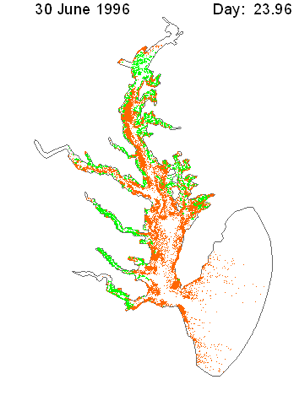 The Larval TRANSport Lagrangian model (LTRANS) was developed by the efforts of Elizabeth North and Zachary Schlag of University of Maryland Center for Environmental Science Horn Point Laboratory. The LTRANS is an off-line particle-tracking model that runs with the stored predictions generated by the Regional Ocean Modeling System (ROMS). LTRANS has also been implemented for a finite element hydrodynamic model (QUODDY). Although LTRANS was built to simulate oyster larvae, it can easily be adapted to simulate passive particles and other planktonic organisms.
LTRANS is written in Fortran 90. It includes a 4th order Runge-Kutta scheme for particle advection and a random displacement model for vertical turbulent particle motion. Reflective boundary conditions, larval behavior, and settlement routines are also included.
The first LTRANS workshop was held on July 17-18, 2008 at University of Maryland Center for Environmental Science (UMCES) Horn Point Laboratory. The workshop was hosted by LTRANS developers and sponsored by UMCES Horn Point Laboratory and Chesapeake Research Consortium (many thanks!). A beta version of LTRANS was presented and tested by workshop participants. LTRANS was successfully run with a variety of Fortran compilers. Among other applications it is now also integrated with the CBFS. Some nice animations produced by the model can be found here.
Chesapeake Community Model Program
http://ches.communitymodeling.org/
Chesapeake Research Consortium
Edgewater, MD
410-798-1283