Chesapeake Community Modeling Program
CCMP Newsletter | August 2010
Volume 3, Issue 4
Introduction
Welcome to the Summer 2010 edition of the CCMP Newsletter! We hope you are having as productive a summer as we are at CCMP. Some of our members have just begun work on a project funded by NOAA and IOOS to develop a test-bed of hypoxia models for Chesapeake Bay. You can read more about it below.
Other items you'll find in this edition-A new model called the Riparian Analysis Toolbox has been added to the CCMP Model Catalog. The model was developed by Matthew Baker and Molly VanAppledorn of the University of Maryland Baltimore County. Our Featured Modeler this edition is Dr. Harry Wang at the Virginia Institute of Marine Science and our Featured Model is the Chesapeake Inundation Prediction System. Please read on and we hope you enjoy it!
As always, if you have any comments or suggestions, please let us know!

Contents
1. CCMP News in brief
2. Open Source on the March
3. Featured Modeler: Harry Wang
4. Featured Model: CIPS
5. Upcoming Meetings
1. CCMP News in Brief
Estuarine Hypoxia Component of the SURA Super‐Regional Modeling Testbed
Updating a story from our last newsletter, several CCMP Steering Committee members have recently begun work on a component of a larger project entitled “Super-Regional Testbed to Improve Models of Environmental Processes on the U.S. Atlantic and Gulf of Mexico Coasts”. This project is funded by NOAA and IOOS through the Southeastern Universities Research Association (SURA). The goal of the larger effort is to address three important issues in the Atlantic and Gulf regions:
- Coastal Inundation
- Estuarine Hypoxia
- Shelf Hypoxia
CCMP Steering Committee members involved in this effort (Carl Friedrichs, Doug Wilson, Raleigh Hood, and Kevin Sellner) will be working on a pilot project under the Estuarine Hypoxia Component to develop a modeling testbed for Chesapeake Bay and adjacent Mid-Atlantic Bight. Other individuals from the Chesapeake research community involved in the component are:
- David Green (NOAA‐NWS)
- Lyon Lanerolle (NOAA‐CSDL)
- Lewis Linker (EPA)
- Carl Cerco (USACE)
- Doug Wilson (NOAA‐NCBO)
- Marjorie Friedrichs, Jian Shen (VIMS)
- Ming Li, Wen Long(UMCES)
- Scott Peckham (UC‐Boulder)
- Malcolm Scully (ODU)
- John Wilkin, Julia Levin (Rutgers)
The goal of the hypoxia component is to provide NOAA, EPA, other agencies, and the larger modeling community meaningful guidance on the relative accuracy, efficiency, portability, and complexity of existing agency and community models for oxygen dynamics in Chesapeake Bay and and for hydrodynamics in Chesapeake Bay and adjacent Mid-Atlantic Bight.
Models being evaluated include “Federal” models (NOAA-CSDL CBOFS2, EPA/USACE CH3D, EPA/USACE ICM, Navy/NOAA HyCOM-NCDOA, NOAA-NWS RTOFS) as well as open source community models (ROMS, SELFE, FVCOM, EFDC, COAWST, MERCATOR). Some of the model variables being evaluated include structured vs. unstructured grids, z- vs. sigma-grids, and resolution vs. speed. Project deliverables include results of model inter-comparisons, strength and weaknesses of model variable evaluation, advice to EPA/USACE on model improvement for the 2017 EPA/CBP modeling effort, and delivery of an interactive web-based summary of the project results to NOAA with recommendations for operationalizing future research-to-agency models.
Riparian Analysis Toolbox
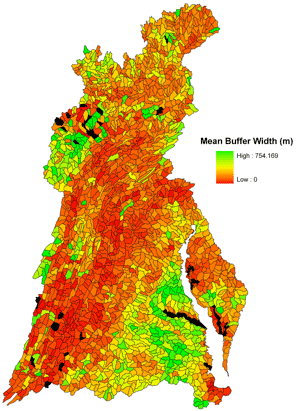 |
| Mean buffer width |
A new model has been added to the CCMP Model catalog - the Riparian Analysis Toolbox. This is a GIS based tool developed by Matthew Baker and Molly VanAppledorn of the University of Maryland Baltimore County. The Riparian Analysis Toolbox contains three categories of tools for analysis of digital elevation, hydrographic, and land cover data within ArcGIS 9x: (1) Riparian Delineation Tools, (2) Buffer Width Calculators, and (3) Strategic Prioritization Tools.
You can read more about the Toolbox and download it here.
CCMP Steering Committee Meeting
 The next CCMP Steering Committee meeting will be held in mid-November at the Smithsonian Environmental Research Center. The current membership of the CCMP SC includes: Raleigh Hood (chair), Bill Ball, Chris Duffy, Claire Welty, Gary Shenk, Doug Wilson, Barry Stamey, Kevin McIlhany, Don Weller, Carl Friedrichs, and Alexey Voinov, with Kevin Sellner and Dave Jasinski attending as representatives of the CRC and the CCMP. Participation in this meeting is open and encouraged. If you would like to attend, please contact Raleigh Hood (rhood@umces.edu).
2. Open Source on the March
Need an Open Source Graphic Design Application?
 While most of the readers of this newsletter are more concerned with writing lines of code for the next iteration of whichever model they are working on and not with editing photos in a graphic design program, we all occasionally have a need for this type of software. Next time you need to touch up or create a graphic for a presentation, consider using one of the open source applications in the list put together by open source blogger Nathan Willis. Even if you don’t need a graphics application, it’s still interesting to see what other members of the Open Source Community are doing.
Rackspace and NASA collaborate on open source cloud platform: OpenStack

In an effort to further the advancement of cloud computing, web hosting service provider Rackspace and NASA are partnering on a project to develop an open source cloud platform – OpenStack. Rackspace is opening the code to its Rackspace Cloud Files software and its Rackspace Cloud Servers technology. NASA will contribute the technology behind its NEBULA Cloud Platform.
In cloud computing, the internet is the cloud. Data, software, and storage exist on servers within the cloud (i.e., - connected by the internet). In its purest form, a user would access software, data, and storage in the cloud using their computer or other network device and an internet browser. The user's computer is therefore just an interface to the cloud which results in a reduced need for processor horsepower and hard drive space on the user's computer. Users can access the cloud on either a subscription or pay-as-you-go system with no need to purchase software.
NASA scientists and engineers benefit from the NEBULA platform in many key areas. Because processors and storage are shared, new projects can get up and running quickly without the need to build new data centers. This results in both cost and energy savings. Projects are also more streamlined because time and costs associated with data center upkeep are eliminated for the individual user.
The goals of the OpenStack project are to drive industry cloud computing standards, eliminate the problems associated with parallel/incompatible technologies from diferent vendors, and to increase the rate of innovation in cloud technology. Both Rackspace and NASA have committed to using OpenStack for their cloud platforms.
You can follow the OpenStack project on Twitter - @OpenStack. Find out more about Nebula at http://nebula.nasa.gov.
Software patents
In a decision that has many open-sourcers cheering, the government of New Zealand has signed into law a bill that will tighten the limitations on items that can be patented in that country. The reason that open-sourcers are happy? One item that can no longer be patented in New Zealand is software. The government agreed with supporters of the law that there is no "inventive step" in software development, just improvment on the work of others. They also agreed that software patents stifle innovation.
The US Supreme Court recently missed an opportunity to take a similar step with US Patent Law in the case of Bilski vs. Kappos. While they ruled that Bilski's software was not a true innovation and could not be patented, they offered no ruling on the overall patentability of software. Proponents of limiting patents on software feel that software patents make it difficult for small businesses to compete because they are constantly at risk of being hit with frivolous patent infringement lawsuits and don't have the deep pockets of larger corporations for legal fees. It is felt that this constitutes a playing field tilted in the direction of larger software developers.
4. Featured Modeler: Harry Wang
 Virginia Institute of Marine Science
P.O. Box 1346
Gloucester Point, VA 23062
- B.A., National Taiwan University
- M.S. & PhD Johns Hopkins University
Harry is a Professor of Marine Science at the Virginia Institute of Marine Science (VIMS) where his research focus is coastal and estuarine physical processes and the consequences of their transport properties. Harry has been working in the Chesapeake for more than two decades, beginning with the advancement of CH3D, the Chesapeake Bay Program’s hydrodynamic model. His current modeling work centers on simulating estuarine and coastal physics and their effects on water quality and sediment and larval transport. He has developed several models for local communities focusing on siting of waste water treatment facilities, guiding possible site selection to minimize local BOD and low oxygen problems for small systems. He has also examined and modeled three layer flows in Baltimore Harbor, and worked with VIMS researchers to identify source and sink areas for oyster larvae in VA embayments. In addition to several other modeling projects, he has most recently been a key hydrodynamic modeler for the multi-institution Chesapeake Inundation Prediction System (CIPS) which provides visualizations of coastal flooding at street level resolution for some of the large urban centers in the Chesapeake basin; Harry is now actively participating in transitioning this skill into NOAA operational products in the recently implemented SURA Model Testbed Project. In the SURA project, Harry will apply the unstructured grid, storm surge, and the SELFE inundation model to the 2008 Hurricane Ike event in the Gulf of Mexico and the 2007 Patriot's Day Nor'Easter in the New England region.
5. Featured Model System: Chesapeake Inundation Prediction System (CIPS)
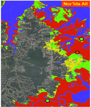 |
| Example of CIPS output showing the water level extent in Hampton, VA and Poquoson, VA during the peak flooding of the November 2009 Nor’Easter for a three model ensemble of atmospheric forcing. |
Our featured model for this issue is not a single model, but an ensemble of weather models, hydrodynamic models, and visualization systems being developed to provide accurate and reliable on-land flooding forecasts for tropical cyclones, non-tropical wind systems such as nor’easters, and other significant wind and precipitation events for the Chesapeake Bay region. The objective of the Chesapeake Inundation Prediction System (CIPS) is to produce “actionable information” of the on-land area to be flooded that the National Weather Service Weather Forecast Offices (WFOs) can incorporate in their operational services to support emergency managers, first responders, and other decision-makers. To develop this forecast guidance system, the CIPS team utilizes:
- An ensemble of atmospheric models as forcing for two hydrodynamic models.
- Integrated hydrologic model river discharge and storm surge for a total water level forecast
- Geospatially-modeled and visualized on-land flooding at street-level scale
- Extensive outreach, communication, and user engagement
- Economic assessment of model adoption and application possibilities
Perhaps one of the most intriguing characteristics of CIPS is that it is a unique collaboration of scientists from academia, federal agencies, and the private sector. On the CIPS team are representatives from the National Weather Service, Virginia Institute of Marine Science, University of Maryland, United States Geological Survey, NOBLIS, Inc., and Weatherflow, Inc.
The CIPS team recently had an excellent opportunity to evaluate the CIPS prototype prior to and during the Veteran’s Day Nor’Easter that hit the mid-Atlantic during November 11-13, 2009. To validate model predictions of the extent of on-land flooding during the Nor’Easter, an innovative observation system was rapidly implemented by the USGS in concert with WeatherFlow, Inc. In advance of this storm, and as per the CIPS concept of operations, the USGS Water Science Centers in MD and VA, in collaboration with emergency management offices in Alexandria, Poquoson, Hampton, Norfolk, and Virginia Beach in VA, and Annapolis, MD, analyzed the projected storm track and successfully deployed a series of on-land water level and barometric pressure sensors. These sensors reported observations crucial to the validation and evaluation of the CIPS forecasted on-land water levels. The gauges were deployed about 24 hours in advance of the November 2009 Nor’easter and were “surveyed-in” after the storm, prior to their removal, for vertical accuracy and precision.
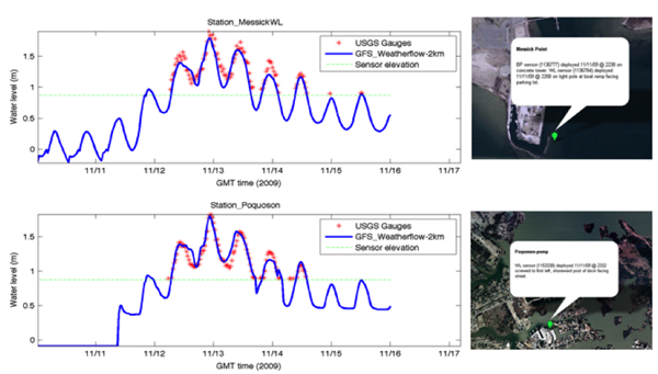 |
| The modeled inundation compared with data measured by USGS inundation gauge. The thin, blue line shows the height of the inundation gauge. The right panel shows the location of the measurement in Google Earth. |
This new, observational data set from the USGS provided a unique opportunity to validate the on-land inundation extent generated in rapid hindcast by the CIPS team hydrodynamic model in the Hampton Roads region (the ELCIRC/SELFE model run by Dr. H. Wang at VIMS). The figure above shows the comparisons of the ELCIRC model results (blue line) to the direct measurements made by the USGS inundation gauges (red crosses) at two locations. The comparison between model results and observations was outstanding for all 6 stations located in Poquoson, Norfolk, and the City of Virginia Beach.
6. Upcoming Meetings
PIHM Workshop – August 2-4, 2010
 PIHM is multi-process, multi-scale hydrologic modeling tool where the physical processes are fully coupled using the semi-discrete finite volume method. The workshop will provide hands-on experience in using PIHM for modeling watershed dynamics. Participants will learn to use a customized GIS interface to PIHM (called PIHMgis) for (i) automated ingestion of model parameters from national databases, (ii) conditional domain decomposition of the model domain, (iii) performing multistate simulations and calibration, and (iv) visualization of model results. The workshop is part of the NSF-funded Critical Zone Observatory (CZO) program at Penn State. A goal of the Workshop is to help stimulate cross-site CZO modeling activities. For more information, go here.
Community Surface Dynamic Modeling System Meeting 2010: “Modeling for Environmental Change” – October 14-17, 2010
![]() The meeting will bring together CSDMS members to present scientific insights in the modeling of surface dynamics and environmental change; new advances in cyber-infrastructure (CSDMS Model-coupling Tool, HPC techniques); development and use of CSDMS models in education (short clinics on EKT products); and allow the CSDMS Working Groups and Focus Research Groups to strategize on the direction of CSDMS for the next 5 years (i.e., the CSDMS Strategic Plan and Renewal.) Carl Friedrichs and Kevin Sellner will be participating from the on-going Chesapeake efforts. For more information, go here.
The meeting will bring together CSDMS members to present scientific insights in the modeling of surface dynamics and environmental change; new advances in cyber-infrastructure (CSDMS Model-coupling Tool, HPC techniques); development and use of CSDMS models in education (short clinics on EKT products); and allow the CSDMS Working Groups and Focus Research Groups to strategize on the direction of CSDMS for the next 5 years (i.e., the CSDMS Strategic Plan and Renewal.) Carl Friedrichs and Kevin Sellner will be participating from the on-going Chesapeake efforts. For more information, go here.
Chesapeake Community Model Program
http://ches.communitymodeling.org/
Chesapeake Research Consortium
Edgewater, MD
410-798-1283