Chesapeake Community Modeling Program
the new CCMP Newsletter | February 2009
Volume 2, Issue 1
Introduction: Discussing the Vision for the future Chesapeake modeling suite
![]() Our discussion of ideas and architectures for the future modeling tools for the Chesapeake is lingering. Just a few messages on the blog so far.
Our discussion of ideas and architectures for the future modeling tools for the Chesapeake is lingering. Just a few messages on the blog so far.
There will be a short session at the end of the CRC Regional Conference on Ecosystem Based Management (EBM): the Chesapeake Basin & Other Systems (Baltimore Marriott Hotel & Conference Center, March 22-25, 2009) to try get managers engaged in this envisioning process. We have also prepared a survey that will be distributed at the conference. You are also welcome to take a look and pitch-in at our online survey.

Contents
1. CCMP News in brief
2. News from other communities
3. Open Source on the March
4. Featured Modeler: Gary Shenk
5. Featured Model: Chesapeake Bay Forecast System
1. CCMP News in Brief
Second Year of Our Newsletter
With this Newsletter we open our second Volume. This is the second year that CCMP is publishing the Newsletter. So far we have sent out five issues on a bi-monthly basis.
There is a remarkably low feedback rate, which makes us sometimes wonder whether the Newsletter is even needed. While there seemed to be a lot of excitement about further open source model and data development during our Symposium last May, the overall engagement of the community has been very slow since then. It might be a good time to discuss CCMP’s future and whether we should focus on something different than Newsletters and Blogs. As always, your input is very welcome.
By-Laws are ready and posted
 The CCMP Steering Committee has approved the CCMP Governance Rules and they are now available here. Bearing in mind the low activity of the CCMP membership, the Steering Committee decided that there will be no need for a general membership approval. Instead the By Laws are enacted by the decision of the Steering Committee, while the membership has the right to call for a vote on changes. Check out the document and let us know if there are any questions.
2. News From Other Communities
First meeting of the CSDMS Chesapeake Focus Research Group
 The Community Surface Dynamics Modeling System (CSDMS) is announcing the first meeting of the CSDMS Chesapeake Focus Research Group to be held April 3, 2009 at the Department of Geography Environmental Engineering (DOGEE), John Hopkins University in Baltimore, MD. The Chesapeake FRG is the first Geographically-Focused Research Group associated with CSDMS. The group is a partnership between CSDMS and CCMP. You can find out more about the CSDMS Chesapeake FRG at this link to the CSDMS wiki: http://csdms.colorado.edu/wiki/index.php/CCMP
So, in addition to the geographical focus, attendance at the meeting will enable you to stay abreast of cutting-edge research developments applicable to many areas of study. The meeting intends to:
- get everyone up to speed on CCMP, CSDMS and model integration pathway that CSDMS is employing (modified CCA for the Architecture and framework, BABEL as the language independent compiler, modified OpenMI for interface standards, etc.),
- get everyone up to speed on appropriate Chesapeake modeling tools in use by the CCMP community,
- get everyone up to speed on the valuable field data that CCMP offers for code testing,
- develop some simple, doable short term, intermediate term and longer term goals for the group, and
- perhaps assign some tasks to the members.
If you would like to attend, please contact us as soon as possible as the Chesapeake FRG is planning to allocate some funds in support of meeting participants
3. Open Source on the March
And the Fight Continues

![]() The on-going attack on Open Source from Microsoft continues. A few years ago the charge was that “Linux and open source violate 235 of Microsoft patents”. In fact on Feb. 22, a San Diego jury delivered a $1.52 billion patent judgment in favor of Alcatel-Lucent against Microsoft. The judgment was about one-third of what Alcatel-Lucent had asked for and it was the largest patent award in history. In spite of that and at that same time MS was also suing ATT for patent infringement. The pressure seems to be continuing with another announcement that Linux could be in violation of 283 MS patents and, as such, could expose customers to undetermined licensing costs.
The on-going attack on Open Source from Microsoft continues. A few years ago the charge was that “Linux and open source violate 235 of Microsoft patents”. In fact on Feb. 22, a San Diego jury delivered a $1.52 billion patent judgment in favor of Alcatel-Lucent against Microsoft. The judgment was about one-third of what Alcatel-Lucent had asked for and it was the largest patent award in history. In spite of that and at that same time MS was also suing ATT for patent infringement. The pressure seems to be continuing with another announcement that Linux could be in violation of 283 MS patents and, as such, could expose customers to undetermined licensing costs.
Now once again Microsoft has leveled a lawsuit against TomTom, the Dutch maker of handy GPS navigational devices, alleging multiple patent infringements. Many see this as a shot across the bow at Linux and open-source software. This is also viewed as Microsoft’s first direct attack on Linux .
So why would MS be so opposed to open source? One explanation is that open source is not just a development methodology. It’s also a distribution model, and one that has the promise of being way more efficient than the one provided by Miscrosoft. It’s in the distribution chain where MS excelled and prospered. If OS is superior in the way it delivers products to customers - then that is a real threat and challenge.
If it’s Open Source it does not mean it’s superb
 According to a recent study the fact that a scientific paper is made available in an open access, open source web outlet, does not mean that it will be read more than if it is published in a commercial and costly publication.
“On average, when a given publication was made available online after being in print for a year, being published in an open source format increased the use of that article by about 8 percent. When articles are made available online in a commercial format a year after publication, however, usage increases by about 12 percent.“
Apparently readers value reputation more than low cost. This is certainly not the case for the developing world, where cost is crucial.
4. Featured Modeler: Gary Shenk
Gary Shenk, CBPO
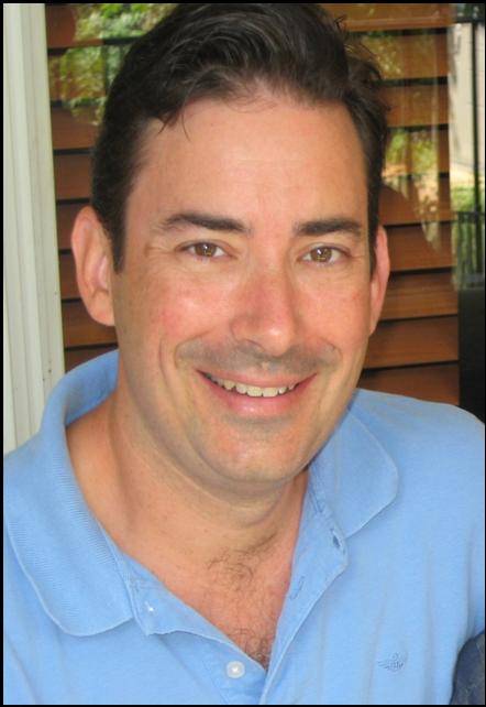 Gary Shenk is the Integrated Analysis Coordinator for the Chesapeake Bay Program. His two areas of focus in this position have been in
automation of routine tasks and the integration of modeling and monitoring. Automation of modeling and analysis tasks is necessary to
meet the increasing demands for information to support the decision making of the Chesapeake Bay Program partnership. Modeling and
monitoring have been more closely integrated to achieve a better model calibration, to decrease error in model scenario analysis, and to site monitoring stations in the watershed.
Gary Shenk is the Integrated Analysis Coordinator for the Chesapeake Bay Program. His two areas of focus in this position have been in
automation of routine tasks and the integration of modeling and monitoring. Automation of modeling and analysis tasks is necessary to
meet the increasing demands for information to support the decision making of the Chesapeake Bay Program partnership. Modeling and
monitoring have been more closely integrated to achieve a better model calibration, to decrease error in model scenario analysis, and to site monitoring stations in the watershed.
His primary modeling responsibility is the application of the watershed model HSPF to the Chesapeake watershed. The current application, known as Phase 5, will be used as the watershed model for the Chesapeake TMDL to be completed in late 2010 or early 2011. The current version, Phase 5.1, is available on the CCMP web site.
The phase 5 watershed modeling system features a flexible software design that allows the user to quickly incorporate new inputs for calibration or scenarios, to run any sub-region, and to incorporate new types of management practices as they are developed. A primary focus has been on the development of automated routines to calibrate HSPF for hydrology, land sediment and nutrients, and riverine water quality.
Gary was one of the first in the Bay Program to buy into the open source concept, and has made the watershed models developed by the CBP open source and available for the community. Gary serves on the Advisory Committee for CCMP and is always active and responsive to the needs of the Chesapeake modeling community at large.
5. Featured Model: CBFS
Our featured model in this issue of the newsletter is: Chesapeake Bay Forecasting System
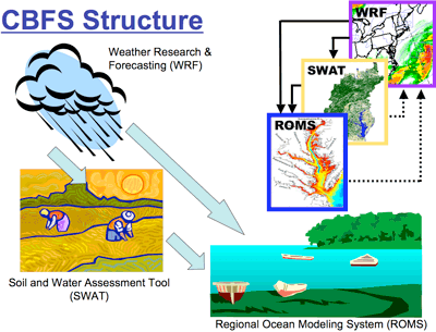 The Chesapeake Bay Forecast System (CBFS) is a prototype regional ESM being developed at ESSIC. The CBFS dynamically downscales global climate forecasts at time scales from sub-daily to inter-annual and decadal. The CBFS consists of regional atmosphere, ocean, biogeochemical and land dynamical models that are coupled together to provide comprehensive forecasts of the environmental behavior of the Chesapeake Bay region.
The atmospheric component of the CBFS is provided by the Weather Research and Forecast (WRF) model, which is coupled to the NOAA land-surface model at 7.5 km resolution in the demonstration phase. At present the National Centers for Environmental Prediction (NCEP) Global Forecast System (GFS) model is used to provide lateral boundary forcing for the WRF 16-day forecasts. The current GFS forced single run, which allows for 3-hour lateral boundary updating during the first week, will continue to be produced, but will be terminated after forecast hour 180. A 2-4 km nested grid will be added over the Chesapeake Bay in this shorter forecast.
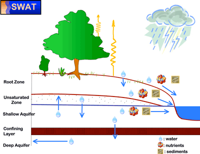 The watershed component of the CBFS consists of the Soil and Water Assessment Tool (SWAT), which is integrated with NOAH and coupled to the WRF atmosphere. SWAT is set up for each tributary of the Chesapeake watershed. The land use types (agriculture, urban, water, wetland, forest, others), crop types for agricultural lands (corn, wheat, rye, etc.), point and distributed sources of pollution and nutrients (chicken and cattle farms, resource losses, sediments from agricultural/construction, etc.), management data (fertilizer loadings, water use), and other details have been synthesized for the Chesapeake watershed starting from 1995 with some future scenario projections of land use. Atmospheric and radiative forcing for NOAH and SWAT is obtained from the WRF model forecasts.
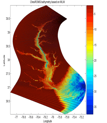 The Chesapeake Bay itself is predicted with the Regional Ocean Modeling System (ROMS) using an embedded marine ecosystem model and an Ensemble Kalman filter assimilation system. Freshwater forcing in forecast mode from all the tributaries is prescribed in the demonstration phase from regression relations between historical runoff data and the NARR precipitation over the catchment area. Atmospheric flux forcing for the ROMS is obtained from WRF model forecasts.
In the demonstration phase, the atmospheric component of the CBFS provides forecasts of 16-day long hourly time series of temperature, moisture and winds at the surface and a number of levels in the free atmosphere, as well as precipitation, evaporation and radiation budget components at the surface on a regular grid with a spacing of 7.5 km for the entire Chesapeake Bay watershed region. In the near future forecasts of atmospheric constituents and air quality parameters such as carbon monoxide, ozone, particulates and pollen and other allergens will be generated with this system.
Land surface forecast products will be soil moisture and temperature, snow depth and density and the water content of the vegetation canopy are predicted by the land surface model. SWAT predicts quantities related to surface runoff, including stream flow (total yield as well as surface runoff and groundwater contributions), sediment load and concentrations, nitrogen load (organic nitrogen, nitrate, nitrite and ammonium), phosphorus load (organic and mineral phosphorus), algal biomass, carbonaceous biochemical demand, dissolved oxygen, soluble and absorbed pesticide output, bacteria, and metal transported out of the tributaries.
The ocean component of the CBFS provides forecasts of currents, temperatures and salinities at a number of levels in the vertical on a regular grid with a spacing of about 3 km. Coupled biogeochemical models provide forecasts of dissolved oxygen (and thus regions of anoxia), chlorophyll, nitrate, and tidal and non-tidal water levels. Linked ecological models create forecasts of location and concentration of sea nettles, harmful algal blooms (Karlodinium, Pseudo-Nitzscia, Microcystis, Prorocentrum), and pathogens (Vibrio Cholerae, V. parahaemoliticus, V. vulnificus), oyster larval transports and fish egg transports. Digital elevation models are used in conjunction with water level forecasts to provide predictions of inundation and storm surge at street-level resolution.
While CBFS is made of open source components, it is yet to become open source itself - something we at CCMP are very much looking forward to. It would be also interesting to see what is the difference between the projections generated by the CBFS and the ones that are available from another high complexity modeling suite developed by the Chesapeake Bay Program. Yet another question is the cost- and effort-efficiency of developing multiple complex modeling suites that seem to have much in common in terms of their architecture, components, and functionality.
Chesapeake Community Model Program
http://ches.communitymodeling.org/
Chesapeake Research Consortium
Edgewater, MD
410-798-1283